


Maple Creek (C-27111)
What are trust lands?
Trust lands are parcels of land granted by Congress to Utah at statehood to support specific beneficiaries, including public schools, universities, hospitals, and reservoirs. Trust lands are not public lands, but are generally open for public use, when possible. Trust lands were allocated specifically to generate revenue to support our beneficiaries. SITLA currently manages 3.4 million surface acres on behalf of our beneficiaries.
ONLINE BIDDING INFORMATION:
Bid Start Time for this Parcel: 10am MDT, June 8, 2023
Bid End Time for this Parcel: 11am MDT, June 13, 2023
CLOSING COSTS:
The closing costs are in addition to the 10% down payment. The cultural resources survey costs may be financed, upon approval. All other closing costs are due from the prevailing bidder at the auction and cannot be financed.
| Appraisal Costs: | $1,800.00 |
| Cultural Resources Survey: | $730.00 |
| Legal Advertising Cost: | $360.00 |
| Sale Processing Charge: | $500.00 |
| Application Fee: | $250.00 |
| TOTAL CLOSING COSTS: | $3,640.00 |
Beneficiary:
The net proceeds from the sale of this property will be deposited into the permanent fund for the beneficiary of Public Schools.
Legal Description:
Township 17 South, Range 1 West, SLB&M
Section 3: SW¼SE¼, SE¼SW¼
Location:
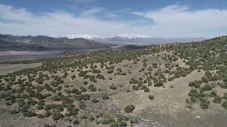
This parcel is located in Sanpete County, west of Ephraim and 9 miles north of Fayette. Yuba Reservoir is located directly east of the property.
Access:
State Road 28 is approximately 0.7 mile east of the property. Access is from a county-claimed road which crosses through the parcel.
Additional Information:
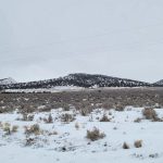
The topography of the property is sloping with a southwest facing aspect, with the highest point being 5,520 feet above sea level. The vegetation of the property is native shrubs, juniper trees and grasses.
Acreage:
80.00 acres, more or less
Water Rights:
No water rights will be conveyed with this property.
Utilities:
The are no utilities to the property, however there is power in the area (along Highway 28).
Zoning:
SL – Sensitive Lands (this zoning is 5 acres per structure with 200′ of frontage)
Financing:
Financing will be offered for this parcel at a variable interest rate of prime plus 2.5% or 7.5%, whichever is greater. A down payment of 10% and closing costs will be due at the auction. The remaining balance can be financed for up to a 20 year term.
Mineral Leases:
None
Surface Leases:
- Easement No. 2291, issued to Sanpete County for roads for a perpetual term
- Grazing Permit No. 23407-16, issued to G&B Land Management, Inc. (these lands will be removed from this permit when the property is sold)
- Range Improvement Project No. 646, issued to Korey Wright (A range improvement project was completed in 2016. This will not be an encumbrance of the sale.)
- Range Improvement Project Application No. 967, submitted by Keith Lyman for a stock water system
Cultural Resource Covenant:
A cultural resource survey has been conducted on this parcel. No significant cultural or historical sites were identified. The property will be without any cultural or historical reservations.
Disclosures:
- Please see the disclosure summary and the certificate of sale template document posted at the bottom of this page for general disclosures which apply to all parcels being offered for sale at this auction.
- All mineral rights will be reserved.
- The sand and gravel on the parcel will be subject to a royalty provision if sold commercially.
- The Utah Geological Survey has submitted the following comment: “Potential geologic hazards in the area that could affect the parcel include earthquake-related hazards associated with the Levan and Fayette segments of the Wasatch fault zone, flash flooding/debris flow, shallow bedrock, problem soils and/or bedrock including shrink/swell and/or collapsible, and indoor radon potential. Prospective buyers should be aware of the potential hazards so they can be addressed in a manner appropriate to the intended use of the property. UGS has general geologic hazard information available at our offices and online at
http://geology.utah.gov/utahgeo/hazards/index.htm.” - The property will be conveyed subject to all valid existing rights.

