


Ford Ridge – Parcel 3 (C-27010)
What are trust lands?
Trust lands are parcels of land granted by Congress to Utah at statehood to support specific beneficiaries, including public schools, universities, hospitals, and reservoirs. Trust lands are not public lands, but are generally open for public use, when possible. Trust lands were allocated specifically to generate revenue to support our beneficiaries. SITLA currently manages 3.4 million surface acres on behalf of our beneficiaries.
ONLINE BIDDING INFORMATION:
Bid Start Time for this Parcel: 9am MDT, June 8, 2023
Bid End Time for this Parcel: 10am MDT, June 13, 2023
CLOSING COSTS:
The closing costs are in addition to the 10% down payment. The cultural resources survey costs may be financed, upon approval. All other closing costs are due from the prevailing bidder at the auction and cannot be financed.
| Appraisal Costs: | $1,802.00 |
| Cultural Resources Survey: | $4,293.00 |
| Legal Advertising Cost: | $200.00 |
| Sale Processing Charge: | $500.00 |
| Application Fee: | $250.00 |
| TOTAL CLOSING COSTS: | $7,045.00 |
Beneficiary:
The net proceeds from the sale of this property will be deposited into the permanent fund for the beneficiary of Public Schools.
Legal Description:
Township 12 South, Range 9 East, SLB&M
Section 32: All
Location:
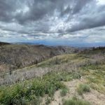
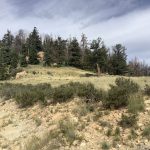
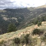
This parcel is located in Carbon County, northwest of the town of Helper on the south facing ridge that separates Spring Canyon (south) from Crandall Canyon (north).
Access:
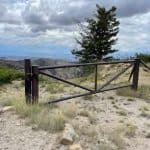
There are no public or SITLA owned vehicular access rights for this parcel. Interested parties should do their own due diligence regarding access to this parcel for their intended purposes.
Additional Information:
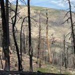
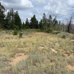
The average elevation of the Ford Ridge property is 8,332 feet with gradual to steep slopes.
Acreage:
662.20 acres, more or less
Water Rights:
No water rights are available to be conveyed with the property.
Utilities:
No utilities are located on site. The closest electrical service is about a mile northwest on Beaver Peak.
Zoning:
WS – Water Shed
Financing:
Financing will be offered for this parcel at a variable interest rate of prime plus 2.5% or 7.5%, whichever is greater. A down payment of 10% and closing costs will be due at the auction. The remaining balance can be financed for up to a 20 year term.
Mineral Leases:
- None
Surface Leases:
- Grazing Permit No. 23063-13, issued to Sacco Brothers Land & Livestock Co. (when sold, this land will be deleted from this grazing permit)
Cultural Resource Covenant:
A historical and cultural resource survey has been conducted on this parcel. No significant sites were identified. The property will be sold without any historical or cultural reservations.
Disclosures:
- Please see the disclosure summary and the certificate of sale template document posted at the bottom of this page for general disclosures which apply to all parcels being offered for sale at this auction.
- All mineral rights will be reserved.
- The sand and gravel on the parcel will be subject to a royalty provision if sold commercially.
- The Utah Geological Survey wants all interested parties to be informed of potential geologic hazards in the region that could affect this parcel including landslides and landslide-prone geologic units, rockfall, stream flooding, flash flooding/debris flow, problems soils and/or bedrock including shrink/swell and/or collapsible, shallow bedrock, and indoor radon potential. Potential buyers can get information from UGS’s general geologic hazard website at: http://geology.utah.gov/
utahgeo/hazards/index.htm. - The property will be conveyed subject to all valid existing rights.

