


Johnson Canyon (C-27131)
What are trust lands?
Trust lands are parcels of land granted by Congress to Utah at statehood to support specific beneficiaries, including public schools, universities, hospitals, and reservoirs. Trust lands are not public lands, but are generally open for public use, when possible. Trust lands were allocated specifically to generate revenue to support our beneficiaries. SITLA currently manages 3.4 million surface acres on behalf of our beneficiaries.
ONLINE BIDDING INFORMATION:
Bid Start Time for this Parcel: 9:40am MDT, June 8, 2023
Bid End Time for this Parcel: 10:40am MDT, June 13, 2023
CLOSING COSTS:
The closing costs are in addition to the 10% down payment. The cultural resources survey costs may be financed, upon approval. All other closing costs are due from the prevailing bidder at the auction and cannot be financed.
| Appraisal Costs: | $2,700.00 |
| Cultural Resources Survey: | $13,113.60 |
| Legal Advertising Cost: | $264.00 |
| Grazing Improvement Reimbursement: | $1,600.00 |
| Sale Processing Charge: | $500.00 |
| Application Fee: | $250.00 |
| TOTAL CLOSING COSTS: | $18,427.60 |
Beneficiary:
The net proceeds from the sale of this property will be deposited into the permanent fund for the beneficiary of Reservoirs.
Legal Description:
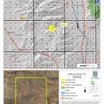
Township 13 North, Range 4 West, SLB&M
Section 10: All
Location:
This parcel is located in Box Elder County, 5 miles west of the town of Plymouth. It is 12 miles northwest of the city of Tremonton; 85 miles north of Salt Lake City; and 8 miles south of the Utah/Idaho state line. The parcel is between I-15 and I-84, approximately 5 miles from each interstate.
Access:
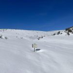
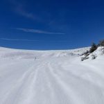
Access is from Johnson Canyon Road, which runs through the middle of the property.
Additional Information:
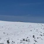
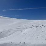
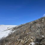
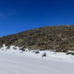
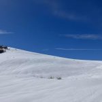
This property has historically been used as open range land. The highest and best use for the parcel is cattle grazing and recreation. It is surrounded by private property. The topography is flat to moderately sloping. The elevation is approximately 5,500 to 5,800 feet. The vegetation is mostly sagebrush and native grasses with minimal trees.
Acreage:
640.00 acres, more or less
Water Rights:
No water rights are available to be sold with this property.
Utilities:
There are no utilities located nearby.
Zoning:
The property is listed as un-zoned. Please contact Box Elder County for more information about zoning.
Financing:
Financing will be offered for this parcel at a variable interest rate of prime plus 2.5% or 7.5%, whichever is greater. A down payment of 10% and closing costs will be due at the auction. The remaining balance can be financed for up to a 20 year term.
Mineral Leases:
None
Surface Leases:
- An application for Easement No. 2648, to be issued to Box Elder County for an unnamed road from Johnson Canyon Road to the southern border of the property for a perpetual term
- An application for Predesignation No. 892, to be issued to Box Elder County for Johnson Canyon Road for a perpetual term
- Grazing Permit No. 22142-08, issued to Young Resources LTD Partnership (these lands will be removed from this permit when the property is sold)
- Range Improvement Project No. 413, issued to Young Resources LTD Partnership (A range improvement fencing project was completed in 2010. An amortized reimbursement for this project will be part of the closing costs.)
- A small weather station is located on the property based on an agreement with the County. This beacon is used to help control wildfires in the area. A future agreement will need to be made between Box Elder County and the purchaser of the parcel.
Cultural Resource Covenant:
A cultural resource survey was conducted on this parcel. No significant historical or cultural sites were identified. The property will be sold without any reservations for significant historical or cultural sites.
Disclosures:
- Please see the disclosure summary and the certificate of sale template document posted at the bottom of this page for general disclosures which apply to all parcels being offered for sale at this auction.
- All mineral rights will be reserved.
- The sand and gravel on the parcel will be subject to a royalty provision if sold commercially.
- The Utah Geological Survey has submitted the following comment: “Potential geologic hazards in the area that could affect the parcels include seasonal stream
flooding, flash flooding/debris flow, problem soils and/or bedrock including shrink/swell and/or collapsible, shallow bedrock, and indoor radon potential. Prospective developers should be aware of the potential hazards so they can be addressed in a manner appropriate to the intended use of the property. UGS has general geologic hazard information available at our offices and online at
http://geology.utah.gov/utahgeo/hazards/index.htm.” - The property will be conveyed subject to all valid existing rights.

